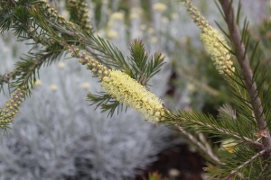
Winters final gasp?

A mild winter that is morphing into spring.

Climatology tells us that we can expect six out of 10 winters when temperatures at the Portland Airport fail to dip below 20ºF. I call these Pelargonium winters because they will generally survive. Our lowest temperature this winter at the airport was 21ºF on December 31st. January was above normal with a striking 17 days with temperatures in the 50ºs and two days of 60ºF. That is more typical of March than January and it answers the question why so many plants are ahead of schedule

The forecast for the next month looks toasty.

Below is our forecast of temperatures for the next month and I have to say that the NOAA has been right on with their forecast of this winter. This gives me hope that we are out of the woods for any truly arctic weather. As we all know in the PNW spring is a whole different animal. Modified polar air from the Gulf of Alaska almost always makes its presence known. Thats 45ºF and frequent showers with small hail through March and April.  Our spring is so cool and unsettled it often amazes me that plants can even wake up and grow. For that we have in part the longer days to nudge things along.
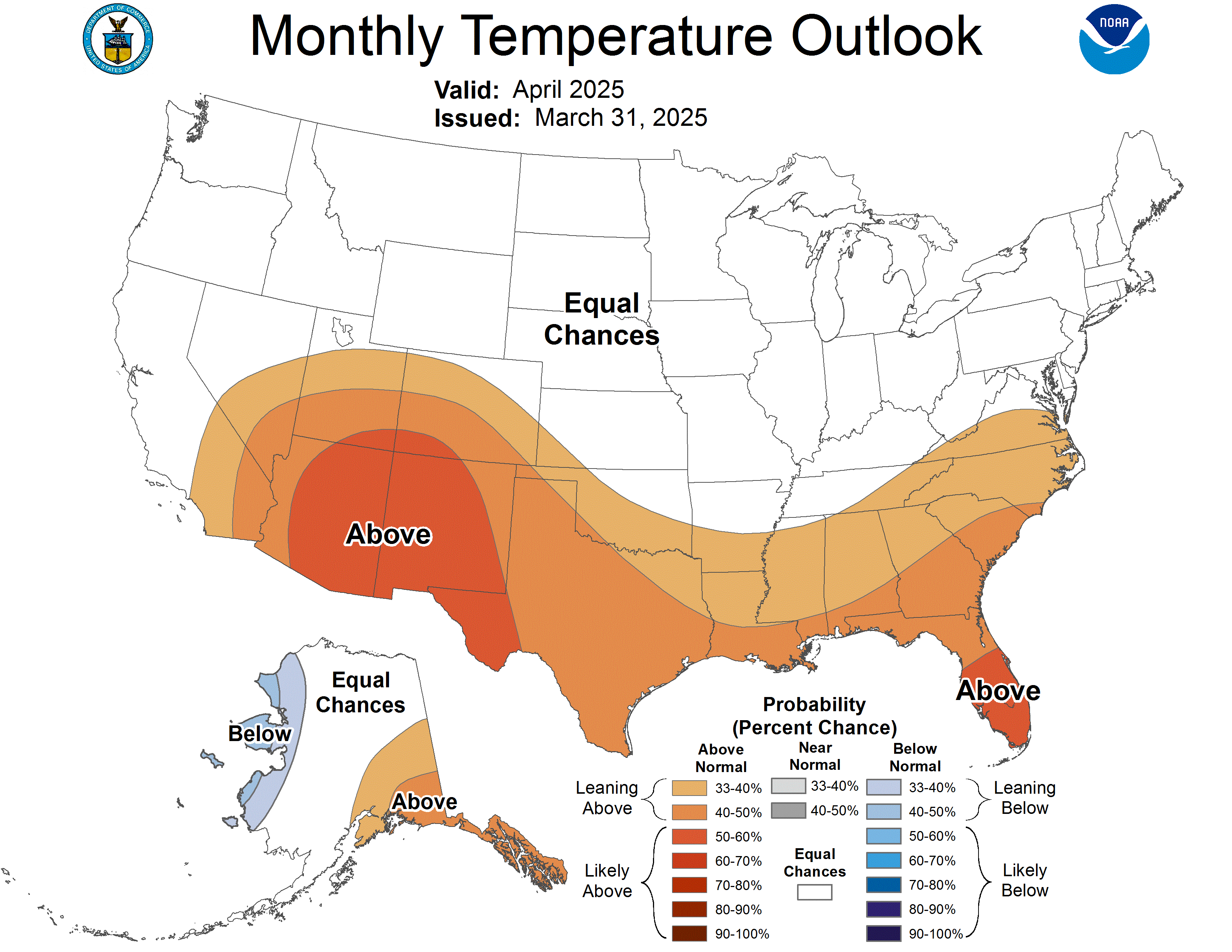
http://www.cpc.ncep.noaa.gov/products/predictions/30day/off15_temp.gif

The warm west and the cold east.

One very broad way of describing the weather which is made up of troughs and ridges is that when there is a ridge in the west there is a trough in the east. That by no means is 100% true but its likely. This year we have seen that repeatedly another reason why winter didn’t really show up.  The midwest and northeast are having completely normal winters in terms of temperature. With blizzards striking both New England and the Chicago area and some near historic snowfall totals.

Is this winter normal?

Yes and no. In terms of average temperatures it has been above normal on a day to day basis. As I said before though mild winters are just as expected as colder than normal winters- thats just how the planet rolls. In many ways the mild El Nino has given us a textbook winter. And not all El Nino winters escape without at least a dose of wintery conditions- but not this year. Precipitation has been just slightly below normal- a hallmark of ENSO. But for the most part this has been a typical mild PNW winter. (Remember 6 out of 10).

Zone 8b and Zone 9a Winter.

A good example of the urban heat island occurs during our coldest weather. The city with concrete and glass absorbs heat during the day and loses it at night. This keeps the low temperatures in the core of the city quite a bit warmer than the rural areas. Also- proximity to the Columbia River Gorge in times of high pressure leads to an east wind drifting over the city. That stirs up the atmosphere and rather than stratifying with cold at the surface and warm air rising temperatures become moderated. In the suburbs and down the Valley temperatures dropped into the upper teens during our coldest episode.  A typical zone 8b winter- so in that things have been perfectly on schedule with averages. Our average annual low in PDX is 20.3ºF and the lowest so far of 21ºF is right where it should be  To be honest I only become concerned when temperatures drop below 15ºF. That seems to be a magic number for the hardiness of a LOT of plants. Phormium, Abutilon for instance are massively damaged below that temperature. A reason why they and many plants we designate borderline hardy. Pair that with high temperatures in the 20ºs and strong east wind and that is the recipe for real damage. True arctic conditions that we can expect 4 out of 10 winters. We were due for a mild winter- its just part of the law of averages.

There is March to get through

In 2011 we had one of the coldest March’s ever. There was frequent snow and surges of cold- though not arctic air.  It culminated in a large snowstorm on the 23rd of March. This caused a lot of damage to trees that were already in bloom or leafing out. This just proves that winter can wait until the end to throw us a curve ball. So far, there is no indication that it will happen this year, but I always keep that in mind. Knowing how good it can be is not nearly as important as remembering how bad it can be. I’m a nursery owner and I have to be prepared for contingencies. As a gardener I plan for the worst and almost always am pleasantly surprised with the results.

Bummer ski year dude

The most dramatic thing about this winter has been the lack of snow at higher elevations. Not to mention that we had one brief snow flurry down here in November. People tend to panic when there are low snow packs. And there is a reason why- but its not often as dire as reported. Our water supplies are very well managed by a series of reservoirs and the Army Core of Engineers  know what they are doing. One dry year doesn’t necessarily mean disaster. And March is typically a huge snow month in the mountains. So, if there was just a complete lack of precipitation and snow pack for several years- then you can worry. To be honest our annual summer drought (June-September) would be considered dire in the summer rainfall areas of the eastern United States. We are used to it and so are our plants- they are not.

Screw it, I’m planting.

So, with an eye to the weather and relying on the law of averages I have already begun planting in my garden. I’ve even plunked in some relatively tender things (Desfontaina spinosa Zn8a) and I’m trusting that the goddess flora will see mild weather. This is by the way a great time to plant hardy plants. The mild winter has resulted in warmer than normal soil temperatures and getting plants in the ground in February means that you will have a good long following of rain into late spring to establish the plants before the summer dry. So, in this mild winter you can take advantage of the conditions and make them work for you. Just be careful not to compact the sodden soil- that is the real danger of winter planting.

Enjoy spring.

As of February 6 I have Camellias, Hellebores, Cyclamen, Heather, Grevilleas, Crocus and Snowdrops all in full bloom. I’m going to enjoy it and watch the weather closely. We trust the forecasts so much that we opened our shop 2 weeks early this year. We have a huge selection of plants just waiting to be shipped to the shop. Drop in and introduce yourself to the plants. Both they and we will be thrilled.

-Paul

Flowers people! We have FLOWERS!

Is winter on hiatus?

This excellent winter for gardeners (not so for skiers) had me thinking about the weather. So far we’ve had typical El Nino conditions. Weak storms, dirty ridges, fog and inversions and mild temperatures.  California has had an improved rainy season. Its all playing out as forecast. And the forecast for the next month is for temperatures above normal and precipitation below normal. So, we shall see, its more than possible that winter is pretty much over.

What happened to all the fish?

El Nino or ENSO (El Nino Southern Oscillation) is a powerful weather phenomenon that occurs typically 3 out of 10 years. Essentially, it is caused by a reversal in wind flow along the equator in the Pacific Ocean. Typically the flow is from east to west. The wind near South America (Ecuador, Peru) blows off shore. This blows the warmer surface waters to the west and results in upwelling of rich, oxygen dense cold water from below. This is a boon to living creatures and this is a fantastic place to fish. Fisherman noticed almost immediately that every few years though that fishing was AWFUL. The ocean became warm (thus less oxygen) and sea life was scarce. It could be so catastrophic to kill even native animals.  This phenomenon was noted as occurring beginning in December- Hence, the fisherman named it El Nino- after the Christ child. Now we know that this 6-9 month long reversal of winds is part of a large pattern and it has specific effects on the weather all around the globe.

El Nino and the Pacific Northwest

The global effects of El Nino are extensive. In the Pacific it can energize the subtropical jet and merge with the polar jet stream- thus wet storms are more prone to move into California- the whole southern United States is wetter. El Nino even quashes the formation of Hurricanes in the Atlantic- good news.  In the northern tier of the US, including us- there is a different set of effects. The weakened polar jet  is often obstructed by a ridge of high pressure. (We are currently as of 1.27.15 under this regime). This prevents storms from moving inland. Less rain. Instead dry conditions appear and often with a strong inversion. An inversion is just that- cold air trapped at the surface (and often foggy and stagnant) and warm air above- it forms a virtual lid on the atmosphere. The atmosphere is inverted.  On 1.25.15 this was in full evidence- would you believe that while we were in the upper 50’s in the Willamette Valley up at the 3,000-4,000′ elevation temperatures were basking in the 70’s?  Not good news for skiers. This lid can trap pollutants at the surface and often fog forms as the lowest elevations cool and the saturation point is reached.

How long?

El Nino typically lasts 6-9 months and its effects can linger a bit longer than that. By the way La Nina is the opposite of El Nino- the wind blows very strong the other direction at the equator and ocean temperatures plummet.  Its effects on us are just as you would guess. Wetter and colder weather. Cold wet springs and summers that are slow to warm. These conditions results in what  gardeners know as bad ‘tomato years’. As far as we can tell La Nina is about 1/2 as likely to occur as El Nino. And there is growing evidence that global warming could spawn more frequent ENSO. Only in the future by judging the past will we know for sure.

My house, my numbers!

People often confuse facts with opinion and the weather is one such casualty. Everyone’s perception is different. Hot for one person is comfortable for another and so on. It occurred to me that it might be good to describe exactly how weather statistics are measured- and what the home gardener can do to REALLY get to know their garden and its micro-climates.

Temperature:  Place your thermometer 5′ off of the ground on the north side of a structure. It should always be in the shade. Yes, the official temperature is the shade temperature. Just several minutes in the sun will wreck your readings. This is especially important if you are tracking the highs and lows.  So no cheating- it must be in the shade. Also, you are taking the air temperature where we live at 5′ above the ground- not at the ground and not 20′ above the ground. 5′ above the ground is where the official temperature occurs.  Personally, I like my Taylor Min/Max mercury thermometer- though there are better more reliable digital units out there. Just be wary of dying batteries- this can skew your results. It goes without saying that the remote sensor for digitally broadcast thermometers be placed in the shade, 5′ off the ground.

Note: The coldest temperature of the day often occurs briefly AFTER the sun has risen so be patient. On the other hand our hottest temperatures (in summer) occurs between 5:00pm and 7:00pm. Wait to reset your thermometer for the truest readings.

Rain: Rain gauges are pretty self explanatory. They must be in the full OPEN air with NO overhead obstructions. Empty them out at the same time every day for the most complete picture. Remember that Portland has HUGE differences in average precipitation with in its boundaries.  The Airport at 90′ above sea level records 37.10″ of rain on average. In the West Hills above 500′ to 1000′ the average is more like 60″ to 65″. Elevation has a huge impact on precipitation. Because we are in Oregon algae can grow in the bottom of your receptacle- If you can’t scrub it out a few drops of bleach will kill it.

Snow measurement: Take a ruler and then find 3 even surfaces covered with snow. Do NOT  immediately go over to a drift of snow and measure it. Take the depth of each place, record it and then divide by three. That average is your official snow depth. Typically, .05″ of precipitation yields 1″ of snow.

Wind: Wind is typically measured 10’+ above the ground. A gust of wind is the average speed over 3 second intervals. A hand held anemometer will record slightly lower speeds than a professionally placed device.  Generally, though you can make estimate  the wind speed using the Beaufort scale of observation. For instance: Smoke rising perfectly vertical is obviously calm. Whistling noises

Agave bracteosa in the snow last winter.

Agave bracteosa in the snow last winter.

through power lines is a gale (33 mph +)  Entire large trees in motion and losing small branches is likely to be 58 mph+- storm force winds. Above that all hell breaks loose and you should be in your house anyway.

Its fun to take the time to record weather in your own garden. If you compare it to your closest reporting station for the NOAA. (There’s a map on the website). You’ll be amazed at the difference.

SHOPPING SEASON IS HERE:

Our shop is open from 10 to 5pm Fridays and Saturdays. We will open with our regular spring hours Thursday through Sunday  (10am to 6pm) starting on February 5.

-Paul

New Bottlebrushes Sweep Oregon Gardens.

Callistemon or Bottlebrush is a genus that we have special interest in at Xera. They may be ubiquitous in California and through out zone 9 – where two red varieties dominate. Callistemon citrinus ‘Splendens’ Zn9a and Callistemon viminalis Zn9b. Neither of these large shrubs, small trees are sufficiently hardy anywhere in the PNW north of Bandon on the southern Oregon Coast. That doesn’t mean we can’t grow some red flowered bottlebrushes. Callistemon (ka’-LIST-ee-mon) which means beautiful stamens- the main structure of the conspicuous flowers-is actually a very large genus- replete with a multitude of  species in their native Australia. They occupy nearly every biome on that continent and are aromatic members of the Myrtle family (Myrteaceae)- which also includes Eucalyptus among other cultivated plants. Its those from the highest, alpine elevations of the interior that thrive in our gardens. There are two reds that have been successful in the mildest gardens west of the Cascades.

Callistemon subulatus 'Dark Red' Is a good red for mild gardens.

Callistemon rigidus ‘Woodlander’s Red’ has become a classic red Bottlebrush for the milder PNW (above)

Callistemon rigidus ‘Woodlander’s Red’ is the most commonly seen red variety. It is hardy to Zone 8a (10º to 15ºF), It requires placement in the warmest locations of a garden- against a south or west facing wall or near the reflected heat of asphalt. It can be damaged in our coldest winters (below 10ºF). Recovery happens though if dead parts are removed  regular irrigation speeds its re-growth during the dry summer months.

IMG_1154

Callistemon subulatus ‘Dark Red’ has some of the deepest sanguine flowers of the genus. It requires the protection of a wall.  (above)                                                  Xera Plants Introduction

Another red flowered bottlebrush that has shown a fair amount of cold resistance is the species Callistemon subulatus ‘Dark Red’. Its a fine, fine textured arching shrub to 3′ x 5′ in our region. Deep red flowers appear on new growth throughout the growing season. It also blooms well in a pot and can be kept in a container that can be moved into protection when temperatures  plunge. It is hardy to about 15ºF and it can vigorously recover if frozen back. (Not all Bottlebrushes have the vigor to regrow and this one does). Place it next to a warm wall, south or west facing. Blooms appear for months. This is a wonderful species for the Oregon Coast (Zn9a).

The Hills are alive with Bottlebrushes

A very hardy species that is  wonderful west of the Cascades is Callistemon pityoides or Alpine Bottlebrush.. As its common name alludes it is from the high mountainous regions of Australia- in snowy, frosty conditions.  It is a very variable species with the two most common traits  fine, needle-like leaves and pale yellow flowers. Nearly 20 years ago, touring a garden in Corvallis I found an Alpine Bottlebrush whose owners pledged that it was growing there and undamaged by cold (that means bouts of 0ºF) for more than 30 years. It is a thin, fine textured shrub with globose small pale yellow flowers that remind me of baby chicks when they decorate each branch tip in May/June and again in September. All selections of this species share the propensity for two seasons of bloom. Callistemon pityoides ‘Corvallis’ grows to 5′ tall and 3′ wide in 10 years. As with all in this genus it absolutely requires full, all day sun to perform. Regular water speeds growth in this species, which is drought tolerant if pressed into that service. It should also be noted that these aromatic and somewhat sparse shrubs are excellent where deer are a problem. These will be left alone or they will be the last thing molested by Bambi in the garden.

IMG_0864

Callistemon pityoides ‘Corvallis’ is an alpine bottlebrush that is the hardiest of the genus to 0ºF. The flowers are adorably reminiscent of little fluffy chicks. 5′ tall by 3′ wide. Zone 7a (0º to 5ºF). (above)  Xera Plants Introduction

One of our finest discoveries of this species is our selection that we have simply christened ‘Excellent’. Its a crazy growing shrub with the finest needle like leaves that would make a pine tree blush. Its greatest attribute is its 5″ long pale yellow wonderful Bottlebrush flowers (again in spring and then fall). Its a winding, arching shrub with great personality and it is a very, very heavy blooming selection .  To 3′ tall and 5′ wide for full sun in any type of soil. Very drought adapted. Cold hardy to Zone 7b (5º to 10ºF)- it shows slight damage below 10ºF- but its recovery is perhaps the fastest of any Callistemon I have grown. This is my own personal favorite Bottlebrush. Its flowers are luminous and cohabitates gracefully with other flower colors. Short of a wacked out conifer, nothing else approaches it in fine textured good looks. New growth in this species is conspicuously furry which is also adorable.

Callistemon pityoides 'Excellent' is just that a subtle flower color and wonderful textural plant.

Callistemon pityoides ‘Excellent’ is just that. A subtle flower color and wonderful textural plant. Fine needle like foliage, superior long brushes decorate this graceful plant in May/June and again in September/Ocober.  (above)  Xera Plants Introduction

Another perfectly hardy species for our gardens is the wonderful Mountain Bottlebrush from Tasmania, Callistemon viridiflorus. This is a remarkably handsome shrub with fantastic leaves, corky, white bark and large beautiful bottlebrush flowers from late May to early July. This is a cold hardy shrub, unperturbed by 5ºF and sports the largest flowers of the hardiest varieties. 1″ wide 4″ long chartreuse/yellow brushes glow from the branch tips and it is a very heavy blooming plant. The nectar  filled flowers (as they all have) are obsessed by hummingbirds for the weeks it is  in bloom. Almost 10 years ago we did a batch from the seed of a parent plant that had survived 0ºF with light damage, just to see what we might get. Out of hundreds we separated out 4 seedlings that had distinctive traits. Our first selection of that brood is a phenomenal plant that we are proud to grow. We have dubbed it Callistemon viridiflorus ‘Xera Compact’. To just 4′ tall and 3′ wide it is an insanely floriferous shrub, thick, vivid 3″ bottlebrush flowers smother each branch tip. The scimitar shaped foliage lines the stems with a pronounced vertical component that is different than the species. This Mountain Bottlebrush has everything for greatness and we are focusing on making as much as we possibly can. The deep green leaves take on maroon tints in winter- which contrasts with the taupe bark in a wonderful way. Look for this great plant at our retail shop- thats the only place it will be available.

Swept Away

Bottlebrush have the unenviable trait of not looking the best in nursery containers- they really find their own in the ground. So with an open mind and a happy heart try out these Aussies in your garden. We are always on the look out for new selections. Allow yourself to be swept away.

Callistemon viridiflorus ‘Xera Compact’ one of our greatest introductions to date. To only 4′ tall and half as wide, it blooms like a fiend popping off brilliant chartreuse yellow flowers for six weeks from late May to early July. So floriferous and its also perfectly hardy to cold down to 5ºF.  (below)     Xera Plants Introduction

Image 6

Unplanned gardens and a summary of the weather year at Portland

Take a quick look at your garden.

I spent this cool and dry January day in my garden tidying up and checking the progress of the garden. Our first real freeze of the year has rendered the soil rock hard and though it dropped to 19ºF in my garden on the coldest night there was very little freeze damage. A few tender things that I slip into the garden were noticeably unhappy. And that is how it should be. 19ºF is just one degree below our average annual low of 20ºF. The coldest temperature was 21ºF at PDX and it went down to 17ºF at Vancouver Pearson Airpark. That is the closest recording station to my north Portland garden.

But, I like to check these things because every freeze, even as inconsequential as this brings new surprises.  I was at the beach for New Years and I stupidly forgot to empty my Koi pot  and it was full to the brim. It froze about 6″ deep and mercifully did not crack. I won’t take that risk again.  Flora had my back.

Limp and sad

One surprise was that my Clematis cirrhosa ‘Wisley Cream’ really got hammered. It was in full bloom and growing happily on a fence. Its limp and discolored and it may be very wounded. Strange, it sailed through 9ºF last year and was unphased. I suspect our warm wet fall and December left it a little lush and perky. We’ll see how this plant recovers. I hope it does because not only do I love it but the over wintering hummers love it too.

Reap what is sown

The longer I garden the more I come to love and cherish plants that reseed themselves. Its a wonderful surprise and can yield really special things. Cleaning up my Hellebores I found a carpet of seedlings- those I dispatched- I like what I have already and they are the product of very careful hybridization by the masters the O’byrnes.  Along side the Hellebores was an equally prolific group of Cyclamen coum seedlings. I had planted the best leaf forms we have grown with an eye to this self propagation. It worked, the majority of the seedlings were all silver or heavily marked swirly leaves. Not only will they stay but I will spread them around the garden. This unobtrusive, tough winter blooming corm is one of the cheeriest parts of the winter garden. I have grown them in full sun as well as dense shade- They thrive anywhere. The only disappointment is when you spear one in the summer when they are quietly dormant. I mark the best ones now with a little blue toothpick. They can go dust dry in summer and all will still be fine.

Surprise, surprise, surprise

Several seedlings of my long dead Grevillea x ‘Constance’ that I have been observing also made it through unscathed. This hybrid of two VERY different species of Grevilleas has yielded some cool things in the past. Grevillea x ‘Neil Bell’ is a seedling of this plant and as I found last winter it was undamaged while its parent plant croaked. Hard. The three new seedlings are all very different in their leaf shapes. I hope they stick around because it might yield a fun surprise. The moral being do not be too hasty to hock out seedlings- a new flower color, form, exceptional thing might be right before you. The also presents the opportunity to share with fellow gardeners. My fecund Daphne tangutica has already yielded several gifts to garden friends.

The Weather Year in Review mild and wild 2014

We already know it was a warm summer and the statistics prove this. Our warmest temperature was 99ºF on two different days July 1st and August 16th. Thats two degrees below our average hottest day which is 101.3ºF. The real story was the warm overnight lows. 2014 set a new record for the most overnight lows above 60ºF- 50. That was 5 days more than the previous record of 45 set in 2013- we may focus on highs and ultimate lows but this may be the real story of global warming. It pays to dig down to the details.  Also, 2014 was the second warmest year ever at PDX.  The record warm year was 1992. So we may not have breached 100ºF but warming can appear in different ways.

Some hard facts just for fun: Statistics courtesy of Portland NOAA

Last day below 32ºF- March 22 normal is March 19th.

First 70º Day- April 7 normal is March 30th

First 80º day- April 30th, normal is May 10th

First 90º day- May 14th, normal is June 16th

Last 90º day was September 20th, normal is September 8th.

First 32º day was November 12th, normal is November 15th

August, September, October were the warmest ever recorded in Portland. See? its not the extremes as much as the details and the trends.

A weak El Nino is chugging along.

If you are a skier you know that this season so far has really sucked. And El Nino is gearing up. January is looking fairly dry and above normal in temperatures.  Remember that an arctic episode can still occur in an El Nino winter but this is shaping up to be typical for a weak ENSO.  We will remain vigilant and post any surprising trends on this blog.  Have a wonderful New Year and happy gardening in 2015!

-Paul

Nature makes us humble and it should.

A Place in History

Yesterdays windstorm will go down in history for several reasons. First, the power of the wind  gusts was not only surprising it was (at PDX) the strongest-67mph- since the great windstorm of December 12, 1995 and that was one of the top three most powerful storms historically in our region. As far as power outages are concerned, however, (100,000 in PDX metro) was far lower than other storms that  actually had lower gusts.

Its not one point, its an average of all the points.

The reason for this is still up for debate but I’m pretty sure that the windstorm we had on October 25 bears some of the responsibility. That windstorm (49mph at PDX) hit when trees- caused by the warmest October in history- were still largely in leaf. That sent them sailing. Also, I suspect that there were stronger gusts that were not registered at reporting stations. (Therein is a topic for endless discussion.) The most important way to view a windstorm is not to focus on one point but to see the reporting stations as a grid. Then you average them all together and come up with more reasonable number- this also explains when damage is widespread, even though the gusts were lower.  In that regard this was the most important windstorm locally since December 2006. That clocked in at PDX at 53mph and knocked 200,000 people off the grid. The strong wind was more uniform and widespread. Still this will be a memorable one.

Damn that was loud! And strong!

Either way the wind freaking howled where I was during the storm. First south of town and then when I returned home. I had to go home because Miles was frightened to death of the wind, poor little guy was shaking and shaking. At our wholesale nursery site it was as impressive of a storm as I’ve seen in our 15 years at that location. Luckily it was just short of what could have been a damaging disaster. (Whew!) Just after I got home my partner and I stood in the backyard and we had several gusts that must have been near 70mph- it was loud and raucous and definitely the strongest I’ve witnessed since 1995. Impressive.

Look for damage now to avoid a surprise in spring.

This is a great time for gardeners to go out and take a good look at their gardens. The wild and twisting winds can cause damage that doesn’t show up for months and maybe even years. Pay special attention to the crotch in trees where two branches originate. This is a typical point for damage  and be aware of any cracks that may not be immediately noticeable.  The majority of tree damage occurs there and it can open up the tree to heart rot- water can get in there and dead tissue inside can kind of grow like an infection. Depending on the size of the tree you may call a tree person who can tell you what to do. Often this kind of damage shows up as a whole section of the tree that has yellow/green leaves not as lustrous as the rest of the tree. I’ve had this happen before and the whole tree eventually died and had to be removed. It was heart breaking. It was in the 2006 windstorm and the tree didn’t totally die for at least 4 months after the event.

Listing this way and that.

Check trees and shrubs carefully. Another damaging aspect is wind rock. Our saturated soils paired with gusting winds can cause the whole thing to rock. Anything that is listing to one side will have to be staked up. Do this sooner than later because there will be more wind. In extreme cases the rocking can tear the roots and cause real damage down the line. Conifers are famous for this. Check them carefully by wiggling the plant to see if there is any give to it. Then look at the base of the tree and be mindful if there is a “well ” around the trunk. The easiest way to deal with this is to right the plant and then stomp the soil around the trunk compacting it. Seriously- its not technical but it has worked for me in the past. Some genus’ that are notorious for this are any Cupressus and taller Arctostaphylos. When I stake plants I ‘ve had excellent results with rebar for larger applications as well as 1″x 1″ wood stakes. Pound these into the ground with a hammer.  A wimpy little piece of bamboo just won’t do. Adhere the plant tightly (by its trunk)  to the stake and use garden velcro- its magic stuff. Garden Fever always carries this and I use it for anything from big trees to floppy perennials. You can easily increase this and re-adhere it as plants grow. Its amazingly strong stuff and lasts for years. I never throw it away but I have a collection in a box in the garage because it is so useful.

It was bound to happen- Weather and the law of averages.

If you want to understand how the weather will be in the future you must look at the past. It has puzzled forecasters the lack of windstorms that we have had in the last 10 years. If you compare it and the velocity to storms in the 50’s and 60’s we had storms this strong nearly every two years and some of them much, much stronger. The October 12, 1962 Columbus Day Storm was the whopper and let everyone just hope this doesn’t happen again. That was 116mph on the Morrison Bridge and 104mph  at PDX before the anemometer simply blew away. Its been speculated that this was a 100 year event and possibly much longer. One reason for the lack of storms may be hiding in the poorly understood North Pacific Oscillation. In its negative phase windstorms proliferate in its positive mode they are less likely. I’ll let weather professionals debate this but it is intriguing. We are in a negative phase at the moment apparently as of 2007. Either way windstorms are part of gardening in the PNW.  They are just as likely as large freezes or heatwaves. It pays to be prepared.

Holidays.

I hope you find your garden un-mangled by the wind and that everything weathered the storm. From all of us at Xera have a great Holiday Season. There are no impending cold spells on the horizon, so relax.

Thanks, Paul

Plants and MADNESS! Its plant MADNESS.

Winter is really a fun time at Xera Plants. We are busily propagating and sowing seed and scouring what seems like the whole world for new plants.  And of course you know that there are thousands of  new, new, new and improved plants waiting to adorn nursery shelves.

We don’t grow a whole lot of patented plants. Not at all because we dislike them and admittedly they are a huge cash outlay. But we are very careful now having been burned on a number of occasions from new plants that failed to perform or were (very) difficult to grow . Imagine a flat of 72 plugs at $4.oo a piece, nearly $300 including shipping and all but a few squeak through winter. To abuse a much bandied term: its unsustainable.

Most of all we are careful because if you run out of a patented plant and you can’t get any more for the season this tends to piss people off. The consumer doesn’t understand and it is infuriating as a supplier.  We really like plants that we can quickly make more of if the demand is there.  And it is not a bureaucratic mess.

We just want to grow good plants.

I really think there should be more species being grown. They are tough, and can be as spectacular as any shrunken deep orange blob with white flowers that you shell out big $$ only to have it become a root weevil festival.  There is fantastic charm in wild species- I was first convinced of this when a friend who grew Rhododendrons years ago showed me the way.  He introduced me to the fantastic range of this genus that was already beautiful without the artificial  intervention of man. They were tougher plants and beautiful in form. The flowers are somewhat subtle, And unless you want your Rhododendron to have buds that fly open and reveal a clown, a magic bunny, in pornographic colors you may be disappointed but I think the charms of the species are wonderful.

Not that we grow them and considering some awful bugs and diseases they are afflicted with I glad we don’t. Doesn’t mean the gardener should shun them.

We have a bunch of new plants to thrill gardeners this spring. Greg and I tend to go for the sturdiest all around garden plants, and we don’t care for fussy, fussy new plants which can be a crap shoot. We want to sell good, solid plants accompanied by the most information we can muster. Fads come and go, but when all of the new plants have been shaken though the system perhaps we will find some amazing, classic, winner. This does happen. See: Geranium x ‘Rozanne’ as as an example.

As for the weather, the next three weeks are looking very mild and wet. As we have seen in CA over the last week, El Nino can bring prodigious moisture there so it looks like a classic scenario. Already systems off our coast are splitting and weakening. One calling card effect of El Nino. So rain in CA and bland and mild here has me seriously wondering if the 23ºF we dropped to on December 2, is our low for the year. In the past cold Novembers that has usually been the extent of the whole winter. It was that way in 1955 and 1985. So we shall see.

Lets hope for milder rather than wilder. We deserve it.

Have a wonderful Holiday Season from all of us at Xera Plants.

We were really lucky and this is why.

El Nino years have a habit of throwing a curve ball into the weather regime just to keep us on our toes. The early (but not record breaking) freeze that just concluded was a close call with truly arctic weather that would have been a catastrophe.

If unmodified arctic air had blanketed the region with widespread highs in the 20’s and lows in the teens such had happened in the infamous early freezes of 1955, 1978, and 1985 and those events resulted in wide spread damage killing and mangling even perfectly hardy plants which were shocked with no proceeding freezes to transition them into dormancy. As proof of the threat of extreme up and down conditions, even native plants are damaged when this happens.

This condition of the atmosphere is called an Omega Block. It sets up shop and completely diverts the jet stream which must  go around this and it sends the flow on a one way ticket straight from the arctic. An omega block over Alaska- such as we have now appeared in October 2006. In that year it only amounted to one single night of extreme cold which mitigated hard core damage. This pattern  forces extensions of the ever occurring  polar vortex south over almost the entire continent. This time the perturbation in the jet stream was massive and it sent a huge volume of incredibly arctic air blasting south and reaching on its western periphery sloshing over the Rockies and then drawn over the mountains and through the Columbia Gorge. For almost 24 hours straight the wind at PDX gusted over 40mph roaring from the east.

We had just passed through the warmest August, September, and October in Portland history. The majority of the rain that fell in October was derived from the tropics and the warmer than normal readings bore this out. A rapid transition to temperatures much colder than we actually had (27ºF at PDX and 19ºF at Vancouver and Hillsboro were our coldest), plants would have been fat and ripe for cold damage.

Also- the second bout of arctic weather last winter that appeared in the first week of February had almost 8 hours of subfreezing strong wind (19ºF with 50MPH gusts) and that resulted in profound damage on plants already weakened by the December freeze. This time there was no subfreezing wind. But the wind, gusting as high as 55mph was damaging enough.

I hope your gardens have been put to rest and that they sleep soundly through winter. As of the beginning of the month we are officially in a mild El Nino with index just barely nudging toward the warmer phenomenon.  May mulch be with you and also with you. It will be interesting to see if this was our coldest weather of the entire winter season. That wouldn’t be unusual at all.

If you are unable to comment on this site, please feel free to comment on this  facebook post.

A warmer than normal winter? Looks like it.

I’ve been pondering all the forecasts that I’ve seen for this coming winter. Without going into painful detail I will state this. Put all together they point to a warmer and drier winter than normal. As you have probably noticed the leaves are tardy to show color this year. That is because not only August, but both September and October were the warmest ever recorded in Portland.

There seems to be no real change in this regime until at least January.  One thing to think of is that last year was abnormally cold- we had two winter blasts- how could we forget?  The cold wave last December was a once in a decade event- in Eugene where it was an astonishing -10ºF at the airport it was a 40 year event.

We typically do not see two cold winters in a row. That is just a fact and beyond that it has no real basis but if you look at the climate record for the last 60 years that is one pattern that holds true. A cold winter is characterized by more than 2 days below 20ºF. Remember that our thirty year average lowest temperature at the airport is 20.3ºF (Zone 8b). Two cold winters in a row has happened in the past but there is a whopping 80% chance based on records from 1940 to the present that supports at least a year of mild/normal winter weather between massive arctic intrusions.

One of the best ways to think about weather is to divide it into averages that gives a better overall picture. For instance, in a 10 year period we typically average 6 winters that fail to drop below 20ºF, (Zone 9) 3 years that drop between 10º and 20ºF (Zone 8)  and one year below 10ºF (Zone 7).  That last figure is becoming more and more rare. The Portland Airport has not seen a temperature below 10ºF since it registered 9ºF back in 1990. Thats almost a quarter century. (It was 11ºF in 1998 and 12ºF in 2009 as well as 12ºF last December. )

Things are quite a bit different in the suburbs. Hillsboro dropped to 7ºF last December, 9ºF in 2009. The average annual low at the Hillsboro Airport is 14ºF (Zone 8a). Its important for gardeners away from the urban core to account for lower temperatures when they choose plants. This is true for Clark County as well.

There is a weak to almost neutral ENSO (El Nino).  Whether or not it gains strength remains to be seen. In a word the weather during an El Nino winter is Bland, Bland, Bland. The northern jet stream weakens and weak troughs are split before then enter the PNW. The weather is warmer than normal (but there can still be an arctic outbreak- its just much, much, lower chances.) Split storms give us mild, dry weather.  We have more than one reason to cheer on El Nino- it strengthens the sub-tropical jet aimed into California providing them with prodigious moisture. I know that everyone wants this to happen to have at least some effect on the historic drought.

Als0- the NOAA predicts a colder than normal winter in the eastern U. S.  This also brings us warmer weather as a ridge remains over the west and a trough over the east ushering arctic Canadian Air far to the south.

So, if you are a gardener expect a milder than average winter- there is always the chance- even if it is much less for an arctic event (and as we know it only takes one arctic night to do all the damage).  If I see anything like that coming I will post it here.

So, in the mean time. The leaves have yet to change color and the next several months do not look to be below climate normals.

The Natives are Restless

Platitudes and Plants

A recent article that I found compelling and posted on Facebook that was originally posted on Huffington Post has me thinking very seriously about the subject of native plants.

It posited the idea that the same plants are planted in similar climates the world over. It was an opinion piece that decried the lack of diversity that imperils native fauna by the lack of native flora.  Here is the link to the story:

‘Just Because It’ll Grow in Your Yard Doesn’t Mean You Should Plant It’ -Lisa Novick

http://www.huffingtonpost.com/lisa-novick/just-because-itll-grow-in_b_3621351.html

Native plants is a term bandied about by well meaning people, it has real practical applications and it is so much more complicated than politically correct buzz words. As with any idea it is subject to both narrow and broad interpretation but to really make an informed opinion I think there should be some background information. I’m not going to espouse an opinion that is right or wrong. Rather, I will give you perameters that I hope will help you as gardeners make up your own mind. At Xera we have our own interpretation of the term and I will describe our philosophy that shapes what we choose to grow and promote.

Vocabulary- Words shape the garden

For a more comprehensive understanding of where plants grow and why there are a group of vocabulary words that I think are useful. Once they are combined they can give the gardener a clearer picture of how to view native plants.

Edaphic- Soil and the composition of soil- this greatly influence the plant community that resides there. I.E. Scree- loose rocky soil. Clay- tightly compacted particles with a heavy silica component. Soils can range from poor nutrient content (Sand) to high nutrient content (humus). Plants are greatly influenced by edaphic conditions. A striking example of this is found in serpentine soils of Southern Oregon. These soils are high in toxic heavy elements such as zinc and nickle. In this environment- where serpentine conditions rise to the surface it can abruptly influence plant communities. Plants not adapted to this stop abruptly and a whole new adapted community dominates. This is a severe example of edaphic adaptation but it makes an important example.

Mesic- Soil conditions with a positive influx of moisture. Plants can also be described as mesic and those rely on a continuous supply of moisture and are less adapted to dry conditions. Mesic designated plants often have lush, foliage with little adaptation to drought. As an example the foliage of mesic plants has little ability to inhibit moisture loss through transpiration. A majority of shade plants are mesic. Plants that are shielded from direct sunlight put more energy into photosynthesis and less into structure that limits moisture loss. They often lose moisture at the same rate they accrue it. These are the plants that require constant summer irrigation in our gardens. Think of native ferns and native Bleeding Heart (Dicentra formosa).

*Transpiration- The loss of moisture through plant foliage.

Hydric-These are soils that are predisposed to seasonal or continuous water inundation. This can be stagnant (anaerobic ) and/or temporarily inundated. Riparian zones- along water ways  typify this description. For instance the plants in these areas are primarily mesic in nature. Two species in Western Oregon that typify Hydric soils are the beloved blue Camas (Cammasia quamash) and Oregon Ash (Fraxinus latifolia).

*Riparian- Wetlands adjacent to rivers and streams.

Xeric- An environment that is starved for moisture. Xeric also describes the adaptation of plants to deal with a continuous moisture loss. Xeric plants may employ a variety of ways to limit this. Hair on leaves, waxy leaves, succulent foliage, leaves held perpendicular to the sun are examples of adaptations of Xeric plants that interrupts the loss of moisture.  In Western Oregon xeric conditions are often found on south facing hillsides. It can also occur in urban areas adjacent to asphalt- which is taking the idea one step further.

What can be tricky is that many (most?) plants do not adhere to one or the other, Xeric or Mesic they all have their own adaptation. But by describing the extremes you get a better idea of how they work. And how they can work for you.

Biome- A region of similar climate and conditions that harbors like flora in a continuous zone. It is defined by conterminous precipitation, temperatures, and soils.

Ecotone- The margins between two biomes- a transition zone.  For instance the boundary between a forest and a grassland. This may be abrupt- in several tens of feet or gradual, many miles.  Differing soil conditions (edaphic), moisture, exposure, elevation, or latitude can drive this change.

These words can give you a rudimentary description of the places where plants grow. Just saying that a native plant will grow in any situation is horribly flawed. Now most people do not really mean to simplify it into one category- and yet you often see “native plant” gardens with species from all different biomes jammed together into one space. It really is a problem that people are not educated to understand the different circumstances that each plant requires. For instance a Biome can extend far beyond our political borders. The Willamette Valley which receives between 35-50″ inches of rain on average and low temperatures annually between 10º and 20ºF is not discrete. The same situation occurs at higher elevations though out Californias mountains. Gradually rising in elevation as you move south. These areas have surprisingly similar flora. Douglas Fir (Pseudotsuga menziesii) Ponderosa (Pinus ponderosa) Oregon White Oak (Quercus garryana) and Western Dogwood (Cornus nutallii) repeatedly show up in this continuous biome south to the lower third of California.  In fact Douglas Fir extends as far south as central Mexico at very high elevations. (It is thought that Mexico is the paleo origin of this species that is so iconic of the Pacific Northwest).

Plants Are on the Move

We may think of the range of plants as permanent- and in a humans lifetime their ranges don’t really extend that dramatically. In the course of natures timeline this is far from the case. In reality species are in nearly constant movement increasing their range in one direction, withdrawing in another- driven by the change in climate that has waxed and waned with the ice ages and interstadials (warm periods between ice ages).

During the cold dry periods of the ice age in Western Oregon species of trees that now dominate the highest elevations of the Cascades dominated all of the lower elevations of our state. At the glacial maxima 11,000 BP the Willamette Valley was a vast forest of Tsuga mertensiana (Mountain Hemlock), Picea englemannii (Engleman’s Spruce), Pinus contorta var. murrayana (Lodgepole Pine)- a current assemblage of flora that now occurs at Government Camp at 4800’+ on the slopes of Mt. Hood. The question this poses is are these locally native plants if only separated by a few thousand years?

The Right Plant in the Right Place

So, if you take the time to learn the correct biome where a plant occurs you will successfully grow many native plants. As an example Ribes sanguineum (Flowering Currant) is a plant of the forest margin ecotone. It thrives on the borders of woods. Luckily it can take full sun as well- to which it has been committed in untold blasting hot landscapes. But forest margins are where it thrives. Trilliums such as Trillium ovatum which decorates the woodlands in early spring is clearly a mesic plant – but it avoids the heat of summer by going safely dormant.

At Xera we have taken a broad approach to native plants. Instead of confining them to their specific political boundaries we try to embrace the whole extension of their occurrence in a biome. To extend that further we seek out plants in similar biomes throughout the world. That is not all of what we grow but its an overall important component. And as we like to say, native plants are great, especially if you know what to do with them.

Summer 2014 Review and Winter 2014/15 what may be?

Lagerstroemia x fauriei 'Yuma' Crape Myrtle

(above) Lagerstroemia x fauriei ‘Yuma’- click for a larger picture.

Crape Myrtles LOVED this past summer- they responded to the extended heat, ample June moisture, and warm over night lows by blooming extremely early and a lot.

Wet, Wet, Dry, Dry, Fry, Fry, Fry

Here are some statistics of the above normal hot summer that we just left. There are some interesting surprises. If you thought it was exceptionally dry- it ended that way but began very differently.  These statistics are from the Portland National Weather Service (NOAA) at Portland International Airport.

We ended the summer with a grand total of 22 days above 90ºF- which is impressive since our average is 13 days. This was the highest number of days since the scorching summer of 2009 (Remember two days of 106ºF, yuck). That year we fried with 27 days. In 2014 we first hit 90º on May 14 when it was 91º and our last day of 90º was 94ºF on September 20th. One important feature of August was not its ultimate high temperatures- though it was above normal in 90ºF days,  it was the nearly continuous stretch of overnight lows (22) above 60ºF.

Sleepless Nights

Our warmest overnight low occurred on August 11th of 69ºF preceding that days high of 99ºF which tied with July 1st which also reached 99ºF for the highest yearly maximum. (Portland’s average annual hottest day is 101.3ºF).  Our average overnight low in August was a very warm 61.4ºF compared with a historical average of 58.1ºF. That might not sound like a big difference but in the world of weather averages its impressive. And in Portland that is downright tropical.

One half wet, one half dry and a parched early Fall

Rainfall- and I’m sure everyone can attest to how dry our gardens are.  This was the big surprise. June (which failed to have any days above 90ºF) was quite a bit above normal  with a total of 2.33″ compared to the average 1.70″.  July also had above normal precipitation with 1.05″ above the average of .65″ (It doesn’t take much to go above average in summer here).  August was dry with just .01″ of rain far below the average of  .67″.  September rounds it out below average at .98″. Normal is 1.47″. This autumns rainy season has been tardy in arriving.

So, if you thought it was dry (and it still is) it was/is a product of several factors. Our heat was very consistent with 80’s and 90’s spaced out evenly over July, August, and September and this was efficient at depleting  soil moisture. August was essentially devoid of rain and this deficit continued well into September. The modest amount of rain that fell in mid September was erased by temperatures that rebounded into successive days in the 90’s. As of early October above normal temperatures and parched soil have left a lot of summer rainfall plants flagging or just plain fried. These conditions are far from historically dry conditions- though it seems extreme to gardeners.

Winter 2014/15 Prognostication

If you would like to know what our winter has in store you should make a trip to the annual Winter Weather Forecast Conference  at 10 am on October 25th at OMSI. Its free and open to the public. Seven locally prominent meteorologists will give their forecasts for winter. This is useful for not just Ski areas and ODOT but for gardeners as well. AND AGAIN it is free. But it gets crowded so get there early. There is quite a bit of meteorological jargon but the forecasts are pretty straight forward. I’ll provide a synopsis on this blog following the meeting.

Now bring on Fall and fingers crossed for a mild winter.